
Kilauea / Hawaii Volcanoes National Park Visitor Guide
Today’s Volcano Update
(updated around 9am daily):
https://www.usgs.gov/volcanoes/kilauea/volcano-updates
Get Free USGS Volcano Notifications:
https://volcanoes.usgs.gov/vns
1) Sign up to receive notifications with your email address
2) Activate your USGS account, by clicking on the link sent to your email address
3) Customize your notification settings, default is All Event Responses which is all activity alerts such as eruption started, and eruption ended. Select updates if you would also like daily/weekly/monthly updates.
4) Select which volcanoes. Default is all, but you can select “All Hawaiian Volcano Observatory HVO Volcanoes” to only get alerts for Hawaii’s volcanos (Kilauea and Mauna Loa). You can come back and make changes to your notifications or volcanoes anytime by visiting this URL.
Kilauea Caldera Halema’uma’u Live Cams
Kilauea Caldera Halema’uma’u Live Cam (West Camera)
Kilauea Caldera Halema’uma’u Live Cam (East Camera)
Kilauea Caldera Halema’uma’u Live Cam (South Camera)
Kilauea Inflation Tilt Tracking
(to review and help predict next eruption event)
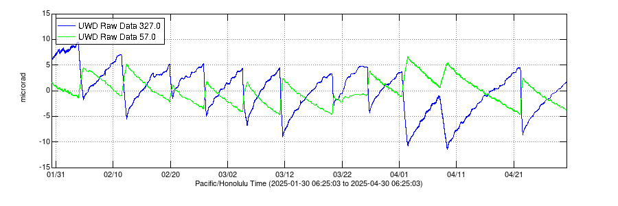
The Blue UWD 300 line in all the graphs is the is the amount of radial tilt up and/or down during a chart period on the western rim of the summit caldera near the current eruption site.
Note the amount of tilt is not an absolute value such as “current elevation” instead it is the amount of positive or negative tilt “inflation” or “deflation” since the last reversal (eruption or end of eruption) during the chart’s time period or since the start of the chart time period if the chart starts after the last eruption such as in the 48hr and sometimes 7 day charts. Therefore the current tilt over a week may be 5 microrands but only 1 microrand over the period of a day.
The green POC 308 line in the charts indicates tilt at Pu’uo’o about 10mi SE from the caldera. Positive changes in the blue line indicate inflation of the magma storage areas beneath the caldera.
Sudden drops in inflation indicate magma release, and typically coincide with the epic lava flow or fountaining events. While lava events are not precisely predicable, you can use the title cycles as an indicator to help predict when the next lava (magma release) event may occur.
Kilauea Past 30 days Tilt Cycles
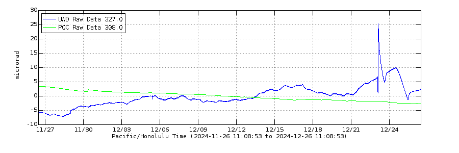
Kilauea Past 7 days Tilt Cycles
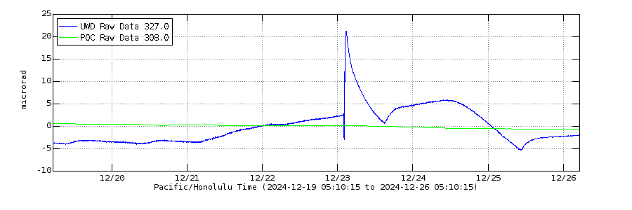
Kilauea Last 48hr Tilt Cycle

As with the monthly chart, the weekly and 48hr charts above can give you a more granular or precise view of the current tilt pattern and trajectory, and can help in planning for your visit to the volcano to view a lava event. The rapid drops in tilt typically represent a lava event, and the gradual rise in tilt represents building magma pressure and typically track to the next lava event. We typically use a combination of the title cycles and the live videos above to plan trips to the volcano. If the lava is erupting and fountaining of course head to the park to view whenever that is happening, however if you are trying to plan for the next lava event, then a good indication of an upcoming event is when the tilt is approaching cycle peak level in it’s recent pattern. Also, the fissure vents (in the live cams above) often start to show some activity such as lava glow, and even small lava splattering, in the day and hours leading up to an event. If there is lava activity in the fissure vents, then an event is likely in the coming hours or day.
Lava Viewing Locations

During a lava event there are usually multiple locations around the crater rim that you will be able to view the lava fountains or flows from. The quality of the view will depend on the eruption, and the location of the eruption vent within the crater. Typically the best viewing vantage point (by far) will be Keanakaoi Overlook and is the case for the current ongoing eruption that started Dec 23rd 2024. If you are just coming into the park for a quick visit, viewing from the lodge/restaurant is very easy although you will be at the farthest point from Halema’uma’u (the eruptive crater within Kilauea) at 2.6mi from the eruption vent. Kilauea Overlook and Uekahua are close (1mi and 1.5mi from the eruption vents) and can both provide views of the upper half of lava fountains if the fountains are high enough. However a full view of the current eruption isn’t possible from these locations due to the due to terrain and the angle of the crater walls, these overlooks currently provide an obstructed view of the lava fountains but you can see the upper sections of the fountains if they are high enough.
Keanakakoi Overlook on the otherhand provides a completely unobstructed direct view of the eruption at a safe but relatively close distance of about 1.5mi from the eruption fissures. To get to Keanakoakoi park at Devastation Trail Head (intersection of Crater Rim Drive East and Chain of Craters Road), and walk about 1mi to the overlook as shown on the map above. Devastation Trail Head Parking is on both Apple Maps and Google Maps. If the parking lot is full you also can usually find a spot to park along Crater Rim Drive, but look for safe flat spot only and do not disturb the rainforest vegetation.
Tips on visiting the Park on any day
Volcano National Park – 30-45min drive (full day or two/three days – plan 4-8hrs per visit – your park ticket is good for 7 days and free entry ater 7:30pm)
- Visit Volcanos National Park during day – Spend time at the visitors center learning about Kilauea and planning your day (Don’t miss!)
- Walk the Steam Vents and Sulphur Banks along the north rim of Kilauea. You can reach the Steam Vents via the Crater Rim trail starting from the Visitors Center or the Volcano House, or drive to and park at Steam Vents. The Sulphur Banks trail starts across the road from the Steam Vents and ends back at the Visitors center. (Don’t miss!)
- Hike the Halema’uma’u Trail descending thru the rainforest down to the Kilauea crater floor. 1.8m round trip, descends 450ft. (If you’re able and up to it, Don’t miss)
- View the Halema’uma’u Crater in Kilauea Caldera from most vantage points around the Kilauea rim.
- Walk thru Thurston Lava Tube. (Don’t miss!)
- Hike the Kilauea Iki Trail if you’re up for a moderately steep but very tropical hike down into the Kilauea Iki crater and back up.
- Walk the Devastation Trail loop trail and view the Kilauea crater from the south rim vantage point (a favorite vantage point!) and see the Keanakakoi Crater along the way
- Hike the Manu Ulu Shield Cone / Pu’u Hulahula loop and see the amazing landscape created by the 1969-1974 Mauna Ulu Flow. 2 mi round trip walk with a 1/4mi hike up the Pu’u Hula-hula cinder cone, if you aren’t able to walk/hike to and up Pu’u Hulahula you can just view the incredible 1969 fissure and Tephra Field just to the right of the trailhead a short walk from the parking area (Don’t miss!)
- Drive the Chain of Craters Road and stop and visit all the incredible past eruption vents & craters (Don’t miss!)
- Walk out to the ancient Hawaiian Pu’u Loa Petroglyphs, off the Chain of Craters Road an easy 1.5mi round trip walk.
- View the Holei Sea Arch at the end of the Chain of Craters Road
- If there is a current active eruption (check the live cams above, also volcanoes national park website or text or call us to see if there is an active eruption during your visit), then we highly recommend to stay till dark (or return in evening) to view the Halemauma’u Lava Lake and the active eruption at night. Viewing conditions will change daily. If there is an active eruption ongoing, there will usually be several vantage points around the Kilauea Caldera to see the eruption directly. Depending on where the current active fissures are, best vantage point is usually Keanakako’i Overlook but often eruptions can be viewed from Kilauea overlook as well. See map. Bring cameras and binoculars. If there is an ongoing eruption we usually will recommend to park at the Devastation Trail Head Parking lot, head past the restrooms and walk out to the Keanakako’i Overlook. It’s about a mile walk to the overlook from the parking lot. Map
- Lunch or Dinner at Volcano House Rim Restaurant. Halema’uma’u Kilauea Caldera view during the daylight hours. Reservations at least several days in advance are usually required for Rim Restaurant. Request a view table. If seating or reservation at Rim Restaurant is unavailable try Uncle Georges also in the Volcano house, casual bar/restaurant with same view as Rim.
- Wine Tasting at Volcano Winery https://volcanowinery.com – 35 Piimauna Dr, Volcano, HI 96785 – Fantastic Hawaii inspired wines and fruit wines, many blended with local Jaboticaba Berries. Tell them Mike and Bo from Pali Hale sent you.
- On your way or back, make a stop at Koana Coffee for specialty coffees and chocolate – voted by Food & Wine Magazine, 2022 best coffee shop in the state of Hawaii. Koana is half way between Pali Hale and Volcanoes National Park – 18-1325 Old Volcano Road, Mountain View, Hawaii 96771 – Open till 2:30pm M-SA (808) 209-4432